


cravant vezelay

theo89
User
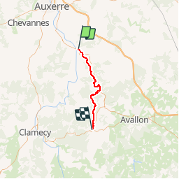

Length
35 km

Max alt
294 m

Uphill gradient
908 m
Km-Effort
47 km

Min alt
108 m

Downhill gradient
730 m
Boucle
No
Creation date :
2016-04-25 00:00:00.0
Updated on :
2016-04-25 00:00:00.0
6h27
Difficulty : Medium

FREE GPS app for hiking
 SityTrail
IGN / Geographical institutes
SityTrail Plus
The world is yours!
About
Trail Walking of 35 km to be discovered at Bourgogne-Franche-Comté, Yonne, Deux Rivières. This trail is proposed by theo89.
Positioning
Country:
France
Region :
Bourgogne-Franche-Comté
Department/Province :
Yonne
Municipality :
Deux Rivières
Location:
Unknown
Start:(Dec)
Start:(UTM)
551848 ; 5281143 (31T) N.
Comments